Posted By
admin | 2020-11-11 17:21:14
| drone, drone cartography, drone rtk
|
Drone Service
The survey of the territory along with the GIS have revolutionized over the past twenty years, the management of territorial issues, environmental and geographical intelligence.
We can carry out all the steps leading to the construction of a GIS system, from traditional survey with theodolites or GPS, the acquisition of the photos, the cartographic, the construction of a GIS system and its publication on the Web.
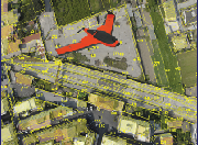
The development of technology (APR Unmanned aerial vehicle) with the integration of new sensors and the GPS RTK allow us to quickly ortho-images and three-dimensional models of the area that can be used as a basis for building of GIS.
|
|
Twenty years of experience in the field of digital photogrammetry associated modern means of flight low cost, available today, considerably expands the opportunities for investigation and survey planning.
The acquisition of images and movies from DRONES, specifically predisposed for the purpose, extends the possibilities of intervention in all circumstancesalways ensuring the reliability geometric at extremely low cost; we are able to provide services of resumption photos and video, for monitoring, mapping, surveying and any other services to support:
- construction field,
- the design,
- supervision and maintenance of industrial plants, wind turbines or photovoltaic,
- civil protection,
- institutions and professionals involved in land protection, cultural heritage and people.
|
|
Areas:
Aerial shots of the jobsite, Monitoring progress of the construction site, Georeferenced aerial mapping, Monitoring of industrial sites, photovoltaic, wind etc., Monitoring archaeological sites, Preliminary study of the areas in which they will operate, Inspection of facilities, Infrared detections, detections multispectral, Intervention in remote and “difficult” areas.
We are able to detect in a short time large portions of the territory.
we can ottttenere point clouds so dense comparable to the results that can be achieved with a laser scanner, but with a much lower investment.
|
|
|
SURVEY OF THREE-DIMENSIONAL:
- quarries
- landfills
- Falesie
- earthworks
- Roads and Railways
MONITORING:
- agricultural
- forest
- fires
- natural disasters
SERVICES:
- Spatial analysis for Major Projects
- Systems integration for GIS
- Generic cognitive movies
PRODUCTS:
- orthophoto mosaic
- Generation model to the point cloud
- Generation DSM / DTM
- Export data for Sw CAD / GIS
|
Video
Request informations