Aerophotogrammetry of Pomigliano D'Arco
Aerophotogrammetry of Pomigliano D'Arco
| Assignment name: Aerophotogrammetry of Pomigliano | Customer: Comune di Pomigliano D'arco (Na) |
| Country: Italia, Pomigliano D'Arco | Duration: 8 months |
| Start date (month/year): 2013 | Completion date (month/year): 2013 |
| Narrative description of Project:
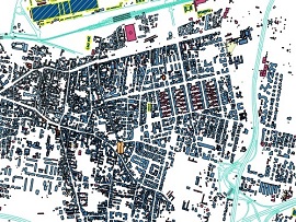
The purpose of the work was the formation of the mapping technique in numerical form 2D-3D with the photogrammetric method on the 1:2000 scale of the entire municipality (area of about 1150 hectares).
This cartography is reported in UTM33N projection, WGS84 datum; The map was carried out by means of direct numerical photogrammetric restitution. The work was carried out according to the following steps:
|
|
 |
 |
Description of actual services provided by your staff within the assignment:
|
|