WebGis and Document Management for the management of the elements of a map.An object is known thoroughly when its history is known;knowledge allows better management.
|
|
|
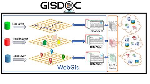
An object can be identified by its position on a map that shows it in its context, and described by an associated card;
The system is the extension of WebGis, it allows you to track events that have occurred or have been programmed, allowing the storage, cataloging and indexing of the documents produced.
Thanks to this, the work team can better manage the site and the "objects" present in it, can efficiently plan future interventions, and share information in real time. Any changes to the system are immediately available to the entire team, improving their efficiency.
It is a dynamic system, which allows the history of the individual elements within their context to be kept updated, giving managers a complete and updated overview of the site.
|
 |
|
|
|
A system of user hierarchies, divided into groups, allows, depending on the permissions granted to the user, to see, add and / or modify the various elements of the system itself.
The entire framework was built using open source components of proven reliability, each a leader in its sector.
The system is multilingual according to modern Web standards.+ |
|
|
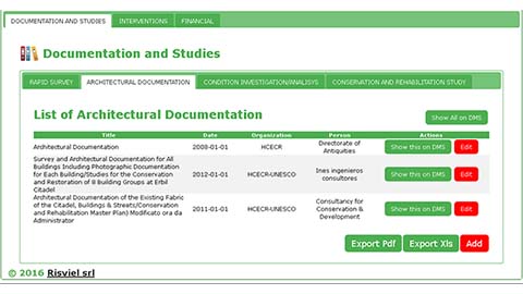
To each vector layer we can associate tables, for example one or more cards that characterize it; further tables can describe its "history", through the actions or events that the object has undergone over time: an inspection, a design, a maintenance intervention, a restoration.
To each of these events we can associate a space (structured or not) within the document manager, in which to collect and catalog the files that document the intervention.
|
 |
|
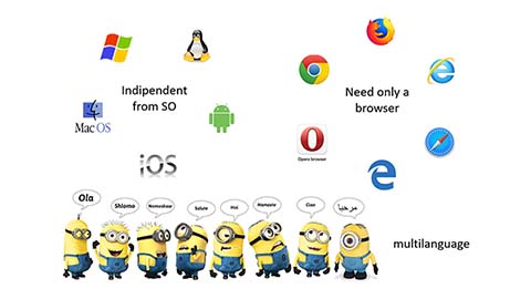 |
the system does not require the installation of any software, it works through any browser, regardless of the hardware and operating system; any system update, or addition of new features, is immediately available to users. |
|
|
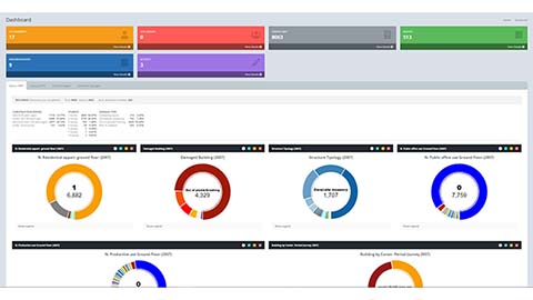
A dashboards allows you to have everything at your fingertips, a general view of the site, the ability to move between the cartographic, tabular and document parts, in an instant and intuitive way.
You don't need to be an "expert" to use the system: through a simple and intuitive interface you can carry out searches, apply filters, in order to select one or more elements that match certain criteria; the result is visible both in table form and graphically highlighted on the map. In this you have all the tools that allow easy navigation: zoom, pan, selection, search, measure. Having the appropriate permissions it is possible to modify or insert further graphic elements directly from the browser.The layer manager allows us to turn on, turn off, change the order, the transparency, in order to have the map that best matches our needs.
A powerful text search engine, associated with the document manager's indexer (reads and indexes all the content of the documents inserted within it), allows us to quickly locate the documents.
The ability to create work flows allows you to automate processes or trigger appropriate actions when an event occurs; such as sending an email, moving documents from one folder to another, requesting approval from a particular user or group of people, etc.
|
 |
|
|
|
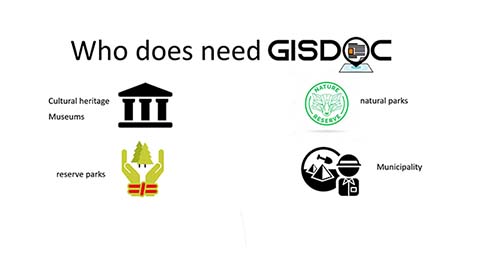
The system is flexible and customizable according to the customer's needs, and can be used by all those who need to manage elements located throughout the territory:
- A section of road, railway, water or sewerage ...;
- A well, a trellis, a tower, a light pole, a tree, a well ...;
- The various elements of an archaeological site, the works in a museum, the buildings of an urban area ...
They are all elements that have a "past" characterized by events to which documents are generally connected, which describe their history, and give us information on the current characteristics of the object and those in the past, on the transformations that the object has undergone over time, why and who made the changes.
The user has the ability to customize the system components; in fact, it is possible to add or delete maps, graphics and tables to adapt the system to the needs of the moment.
Data security and privacy is guaranteed by a robust access control system that allows maximum freedom to share documents: you can share a document with everyone, even on social media, or not share it at all.
|
|
| Download brochure |
|